

Nuweiba city History
Firstly, Nuweiba (also spelled: Nueiba; Arabic: نويبع, IPA: ) is significantly a coastal town in the eastern part of Sinai Peninsula, Egypt, located on the coast of the Gulf of Aqaba.
Historically, it is in the Asian part of Egypt, and the area was inhabited by two different ancient Bedouin tribes. The Tarabin to the north, and the Muzeina some 8 km (5 mi) to the south. After the Six Day War when Israel occupied the area, a small town was established just 1.5 km (1 mi) south of Tarabeen under the Hebrew name of Neviot (Herbrew: נביעות). After the departure of the Israelis, former Egyptian President Hosni Mubarak expanded the settlement. Nuweiba Port, some 7 km (4 mi) to the south, was established and developed, with several car ferries running every day to Aqaba in Jordan by the Arab Bridge Maritime company, and with a small town growing up around it.
In addition, Nuweiba castle (or Newibah castle) built on top of the remains of a still older castle in 1893.
Geography of Nuweiba city
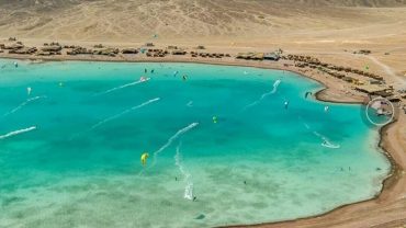
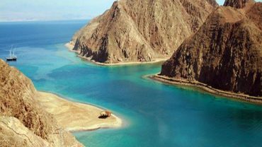
Firstly, Nuweiba lies on a large flood plain measuring about 40 km2 (15 sq mi). Between the Sinai mountains and the Gulf of Aqaba, and is located some 150 km north of Sharm el Sheikh. 465 km (290 mi) southeast from Cairo and 70 km (40 mi) south of the palastine–Egypt border separating Taba and Eilat.People built Nuweiba Port in 1985 on the Gulf of Aqaba, and serves as a ferry port as well. Facilitating between Jordan and Egypt.
Climate
Koppen Geiger climate classification system classifies its climate as hot desert (BWh).
Most precipitation falls in February.
|
Nuweiba
نويبع
|
|
|---|---|
|
coastal town
|
|
 |

Comment (0)